This publication is categorised as a CSO Frontier Series Output. Particular care must be taken when interpreting the statistics in this release as it may use new methods which are under development and/or data sources which may be incomplete, for example new administrative data sources.
A range of classification systems are in use for land cover, land use, ecosystems, and habitats. The classification system used will depend on the user’s requirements and the level of information available. In this publication, we use the draft EU ecosystem typology proposed by Eurostat, which includes the ecosystem types 'Rivers and canals' and 'Lakes and reservoirs'. Table 6.1 shows the 12 draft ecosystem types.
| Table 6.1 Draft EU ecosystem typology | |
| Category | Ecosystem |
|---|---|
| 1 | Settlements and other artificial areas |
| 2 | Cropland |
| 3 | Grassland (pastures, semi-natural and natural grasslands) |
| 4 | Forest and woodland |
| 5 | Heathland and shrub |
| 6 | Sparsely vegetated ecosystems |
| 7 | Inland wetlands |
| 8 | Rivers and canals |
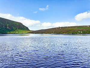
| 9 | Lakes and reservoirs |
| 10 | Marine inlets and transitional waters |
| 11 | Coastal beaches, dunes and wetlands |
| 12 | Marine ecosystems (offshore coastal, shelf and open ocean) |
The best available data at a national level for land cover statistics is the CORINE Land Cover (CLC) dataset. Ireland’s CORINE Land Cover dataset is produced by the Environmental Protection Agency (EPA) for the European Environment Agency (EEA) using satellite imagery from Copernicus and national level data, including data from the Department of Agriculture, Food and the Marine, Coillte, and the Forest Service. It is a comprehensive dataset giving full coverage of the country, with broad land cover classes providing a useful overview of the land cover types in Ireland. There are some limitations to its use for developing ecosystem accounts: it is designed to be a land cover product rather than an ecosystem map, the land cover classes are not refined enough to distinguish between some types of ecosystems, and the minimum mapping unit of 25 hectares means that a lot of detail is lost, especially for linear features such as rivers. To overcome this, we also use additional national level data sources to examine river and lake ecosystems in more detail. The two most recent CORINE Land Cover datasets cover 2012 (CLC2012) and 2018 (CLC2018).
The linkages between CORINE Land Cover Classes and draft EU ecosystem types are shown in Table 6.2.
| Table 6.2 Crosswalk between CLC land cover classes and draft EU ecosystem typology for 'Rivers and canals' and 'Lakes and reservoirs' | |||
| CORINE Land Cover Class | CORINE description | EU ecosystem typology: level 1 | EU ecosystem typology: level 2 |
|---|---|---|---|
| Water courses | Natural or artifical water courses serving as water drainage channels. Includes canals. Minimum width for inclusion: 100m. | 8. Rivers and canals | 8.1 Rivers |
| 8.2 Canals, ditches and drains | |||
| Water bodies | Natural or artifiical water bodies with presence of standing water surface during most of the year. | 9. Lakes and reservoirs | 9.1 Lakes |
| 9.2 Artificial reservoirs | |||
The EPA WFD data provide much more information on the location of rivers in Ireland than the CORINE dataset. The format of the EPA WFD rivers data means that we can only report on length of rivers, not on area. For linear features such as rivers and canals, the length is an important attribute. For lakes, the area of each mapped lake is available.
Data used for this publication were downloaded from the EPA's Geoportal. Rivers were mapped using the River Network Routes data (metadata), and Lakes and Reservoirs were mapped using the Lake Segments data (metadata). A subset of the canal network was mapped using the WFD Canal Waterbody Ecological Potential 2013-2018 data (metadata). The data are based on OSi Discovery Series data (1:50,000 scale). The EPA's mapping work was started in 2002 using OSi data gathered pre-2000. Some smaller rivers and lakes have been added in updates since then. The latest revision of the River Network Routes data was in 2017, and the latest revision of the Lake Segments data was in 2012.
Different types of river and lake habitats can be classified using the Heritage Council's Guide to Habitats in Ireland classifications (also known as Fossitt classifications). The different types of rivers and lakes found in Ireland, together with correspondence with draft EU ecosystem types and Habitats Directive Annex I habitats, can be found in Table 6.3.
| Table 6.3 Fossitt and Habitats Directive Annex I habitats found in Irish rivers and lakes | |||
| Draft EU ecosystem type Level 1 | Fossitt Level 2 | Fossitt Level 3 | Correspondence with Annex I |
|---|---|---|---|
|
Lakes and reservoirs |
Lakes and Ponds | Dystrophic lakes | Natural dystrophic lakes and ponds (3160) |
| Acid oligotrophic lakes |
Oligotrophic isoetid lake habitat (3110) |
||
| Limestone/marl lakes | Hard-water lake habitat (3140) | ||
| Mesotrophic lakes | Rich pondweed lake habitat (3150) | ||
| Eutrophic lakes | |||
| Turloughs |
Turloughs (3180) (priority habitat) Chenopodion rubri (3270)1 |
||
| Reservoirs | - | ||
| Other artificial lakes and ponds | - | ||
| - | Mixed Najas flexilis lake habitat (3130)2 | ||
| Rivers and canals | Watercourses | Eroding/upland rivers |
Vegetation of flowing waters (3260) |
| Depositing/lowland rivers | |||
| Canals | - | ||
| Drainage ditches | - | ||
| 1 In Ireland this habitat is found mainly in turloughs. | |||
| 2 No clear link with a single Fossitt habitat. | |||
The eight Annex I river and lake habitats that occur in Ireland are described in Table 6.4.
| Table 6.4 Annex I freshwater habitats found in Ireland (descriptions taken from NPWS Article 17 reports) | |||
| Annex I habitat | Description | ||
|---|---|---|---|
| Oligotrophic isoetid lake habitat (3110) |
Photo: Áine O'Connor |
This is a soft-water, nutrient-poor and species-poor habitat. The vegetation is dominated by quillwort (Isoetes lacustris) or water lobelia (Lobelia dortmanna). It is frequent where peatland overlies acid bedrock and is found along sheltered shorelines or in upland lakes such as corries. pH is often <6.5. It can co-occur with two other Annex I habitats, the more species-poor Acid oligotrophic lake habitat and the more species-rich Mixed Najas flexilis habitat. | |
| Mixed Najas flexilis lake habitat (3130) |
Photo: Áine O'Connor |
This habitat occurs in moderate alkalinity lakes with clear, low-nutrient waters. Najas flexilis (an Annex II species) is a character species, and Potamogeton perfoliatus and Isoetes lacustris are also characteristic. pH is close to neutral (pH 7). Vegetation can occur to a depth of 8 meters. It can co-occur with Oligotrophic isoetid lake habitat, Hard-water lake habitat, and Rich pondweed lake habitat. | |
| Hard-water lake habitat (3140) |
Photo: Áine O'Connor |
This habitat is found in lowland marl lakes over limestone bedrock, lakes and ponds in turloughs, fens and calcareous sands associated with machair, as well as in quarries and canals. The habitat is dominated by algae, in particular stoneworts (Chara spp.). Stonewort diversity can be high, and include rare and threatened species. A diverse cyanobacteria-dominated curst is also characteristic of the shoreline of marl lakes. The water is generally very clear and highly oligotrophic, and vegetation can occur to a depth of 10 to 11 meters. | |
| Rich pondweed lake habitat (3150) | This habitat generally occurs in lowland, base-rich lakes in productive catchments, and it is characterized by the high abundance and diversity of pondweeds (Potamogeton spp.). It is likely to be associated with mesotrophic water, with neutral or higher pH. | ||
| Acid oligotrophic lake habitat (3160) |
Photo: Áine O'Connor |
This habitat occurs in natural dystrophic lakes and ponds, usually found in blanket bogs or wet heath. While usually botanically species-poor, there can be relatively high invertebrate diversity. Typical plant species include Sphagnum spp., bulbous rush (Juncus bulbosus), pond bog weed (Potamogeton polygonifolius), bogbean (Menyanthes trifoliata) and bladderworts (Utricularia spp.). The endangered Downy emerald dragonfly (Cordulia aenea) is one of the characteristic invertebrate species. | |
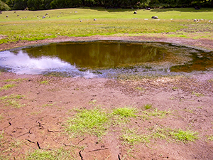
| Turloughs1 (3180) |
Photo: Nova Sharkey |
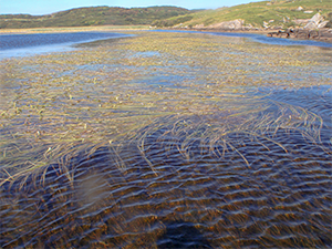
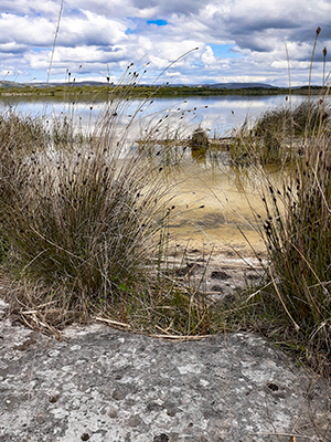
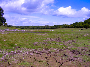
Turloughs are temporary lakes that occur in limestone depressions. They are usually flooded, primarily by groundwater, in the winter, and dry during the summer. The vegetation of turloughs ranges from wetland vegetation communities in the bottom of the depression, to communities more characteristic of drier limestone soils in the upper areas. Turloughs can include other Annex I habitats, including Hard-water lake habitats, Alkaline fen, Chenopodion rubri, and Limestone pavement.Turloughs are important winter feeding grounds and breeding grounds for some species of waterfowl and wading birds. They are also important for aquatic invertebrates, and for species of bare ground. | |
| Chenopodion rubri (3270) |
Photo: Nova Sharkey |
In Ireland, this habitat is mainly associated with riverine turloughs, where the floodwaters recede late in the season or there is summer flooding. The habitat is found on damp mineral soils, and typical species are fast-growing, short-lived annuals that can complete their life cycle during the short dry phase. | |
| Vegetation of flowing waters (3260) | This habitat type has a broad definition, covering a range of types of water courses. In Ireland, the two areas of highest conservation interest are lowland depositing and tidal rivers, and unmodified, fast-flowing, low-nutrient rivers. Important communities also occur in groundwater-fed, base-rich oligotrophic rivers. | ||
Learn about our data and confidentiality safeguards, and the steps we take to produce statistics that can be trusted by all.