
This publication is categorised as a CSO Frontier Series Output. Particular care must be taken when interpreting the statistics in this release as it may use new methods which are under development and/or data sources which may be incomplete, for example new administrative data sources.
The System of Environmental-Economic Accounting - Ecosystem Accounting (SEEA-EA) framework was formally adopted by the United Nations Statistical Commission in 2021. It outlines a comprehensive, spatially based statistical approach for quantifying how ecosystems relate to and interact with the economy and human well-being. This is done by accounting for the physical flows of a wide range of different ecosystem services, the quantity of which is determined by the extent and condition of ecosystems in a given accounting area. From an accounting perspective, the service is ‘supplied’ by ecosystems and ‘used’ either directly by an economic unit (i.e. business, government or household) or as an intermediate service by an ecosystem asset (i.e. an area of cropland). Following a recent amendment to Regulation (EU) No 691/2011 on environmental economic accounts, it will be mandatory to report ecosystem accounts to Eurostat in line with SEEA-EA for seven different ecosystem services beginning in 2026. One of these is crop pollination, and this release uses the current methodology, as proposed by Eurostat, to produce accounts for the service for the year 2018. Note, at the time of this publication, the methodology is still subject to revision. Although any revisions are likely to be minimal, this methodology should be regarded as under development.
In EU Regulation No 691/2011, the crop pollination ecosystem service is defined as a ‘provisioning service’. This differs to SEEA-EA, in which pollination is considered as a ‘regulating and maintenance service’. Therefore, the crop pollination service, as defined in the Regulation, considers only pollination as it relates to the provision of crops – it ignores the much larger, general role played by pollination in the regulation and maintenance of ecosystems and habitats. The crop pollination service is considered an ‘of which’ item within the crop provisioning ecosystem service and the Regulation further defines it as:
‘The ecosystem contribution by wild pollinators to the production of the crops above. The contributions shall be reported in tonnes of pollinator-dependent crops that can be attributed to wild pollinators, by type of crop for the main types of pollinator-dependent crops comprising fruit trees, berries, tomatoes, oilseeds and ‘other.’’
The breakdown of the service supply is required for each ecosystem type described at level 1 in the new EU ecosystem typology, whereas the use of the service is ‘intermediate consumption of the agricultural industry’. By referring to wild pollinators, the ecosystem service is assumed as the supply of pollination primarily by ‘wild bees and hoverflies but also some species of wasps, butterflies, beetles and moths’. Ecosystems support these organisms through the provision of resources, such as suitable nesting sites, over-wintering habitats, nesting materials, larval microhabitats, and floral resources. As defined in SEEA-EA (7.34), the supply of the pollination service can therefore be assigned to ecosystem types because this is where their nesting habitats are located.
The service is calculated using a geospatial model to link the locations of the pollinator nesting sites to the locations of the pollinator-dependent crops. The model (and therefore the service) is dependent on three main factors and one optional factor:
The first step in estimating the service is determining the extent of suitable pollinator habitat, as provided by each ecosystem type. Habitat suitability is assessed and scored per hectare of ecosystem type, taking into consideration landscape features and land management practices as well as the floral and nesting attractiveness of each ecosystem and crop type. Landscape features include different linear features, such as roads, hedgerows and treelines which can affect the likelihood of habitat occurrence. Land management practices, such as whether an area of land is managed as a traditional hay meadow or is intensively grazed by livestock, can also impact the likelihood of habitat occurrence.
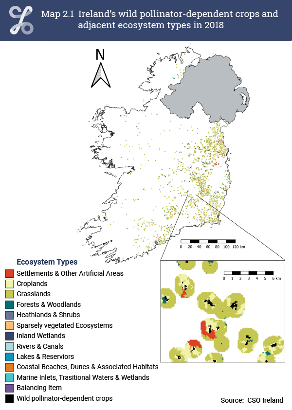
Although there is clear merit in producing a national pollinator habitat suitability map, in practice suitability was assessed only for ecosystems within a 1 km radius of the pollinator-dependent crops (Map 2.1). This corresponds to the maximum pollinator flight distance, meaning that habitat suitability outside of this radius is not assessed. It is worth mentioning here that the geospatial model distinguishes between long- (e.g., bumblebees) and short-distance pollinators (e.g., solitary bees). It does so by producing a separate habitat suitability map for each group. This allows for model parameters for landscape features, floral and nesting attractiveness to be adjusted to reflect differences between the two pollinator groups. For example, certain crops may be assigned a lower floral attractiveness score for short-distance pollinators, which tend to have shorter tongues. Crucially, the short-distance model only considers habitats which are within a 0.2 km radius of the pollinator-dependent crops. When allocating the pollinator-dependent yield (i.e., tonnes harvested) from a particular field of crops to nearby habitats (i.e., hectare units of ecosystems) which have been determined to be suitable, yields are assigned first to available short-distance pollinator habitats. Then, any remaining areas of field which were not within range of a short-distance pollinator habitat are assigned to any available long-distance pollinator habitats. Therefore, the model assumes long-distance pollinators to occupy an ecological niche and only forage fields which are within reach but have not yet been foraged by short-distance pollinators. This approach is based on the ‘neutral theory’ of species-abundance distribution in ecology.
Since the foraging activity of pollinating insects is highly dependent on the weather, the pollination model needs to accommodate variation in relevant weather conditions at the locations of the pollinator-dependent crops. The two relevant weather variables in this case are temperature and solar irradiance, values for which need to be determined at each crop location. Importantly, the values are taken as the average across the flowering period of the crops – that is to say, levels of foraging activity outside of this period are not relevant.
Geospatial species distribution data can be incorporated into the model, which can express the probability of finding populations of insect pollinators in a given location. Results from The Irish Pollinator Monitoring Scheme may provide this data, but it is not yet available at the time of this publication. It is worth mentioning that reporting requirements for the EU Nature Restoration Law may expedite the quality, frequency and release of this data given it will require regular monitoring of pollinator populations to assess whether their decline will have been reversed by 2030. In the meantime, habitat suitability, as assessed and quantified by the model, is used as a proxy of pollinator occurrence.
After mapping and assessing the suitability of pollinator habitats adjacent to crops which are pollinator dependent, the next step is to attribute to them the yields of those crops. This means the yield associated with a particular crop field is distributed to all nearby ecosystems (i.e. within a maximum distance of 1 km) which the model has determined to provide suitable habitat. Moreover, the yield is distributed proportionally to a habitat suitability score which is calculated by the model.
The value of the crop yield (given in tonnes) that is distributed to nearby ecosystems depends on the type of crop and how much of its harvest is expected to be pollinator dependent. A crop is pollinator-dependent if wild insect pollinators add to an increased harvest of its fruit or seeds, which are then used for fibre production, fodder, energy or grazed biomass. For these accounts, 27 different crops (see Background Notes) for which geospatial and yield data (actual or imputed) were available fit this definition. The proportion of the annual yield from these crops which can be expected to be pollinator dependent is then determined using empirically derived pollinator yield contribution factors. The annual pollinator-adjusted yield for a given crop, for example apples, can then be distributed evenly across all fields within the ecosystem accounting area (i.e. Ireland) which grew apples in the same period (in this case, 2018). It is this yield that is then distributed proportionally to adjacent ecosystems which were modelled to harbour suitable pollinator habitat. As a final step, for each crop type the yield is then summed across each ecosystem type, giving the final ecosystem yield contribution.
Learn about our data and confidentiality safeguards, and the steps we take to produce statistics that can be trusted by all.