
Ireland’s Marine Ecosystems extend to 71.3 million hectares, more than 10 times greater than the land area of just over 7 million hectares (see Ecosystem Extent Accounts 2024).
Deep-Sea Ecosystems covered the largest area, at 41.1 million hectares, or 57.7% of the marine ecosystem accounting area. The next-largest ecosystem types were Continental & Island Slope at 15.2 million hectares (21.3%) and Sublittoral Sediments, at 14.2 million hectares (19.9%). Marine Macrophyte Communities covered 40,400 hectares or around 0.1% of the total marine ecosystem area, while Biogenic Reefs & Animal Forests covered 152,600 hectares, around 0.2% of the total area. Anthropogenic Structures & Modified Ecosystems covered 12,000 hectares (Table 2.1, Figure 2.1, Map 2.1).
| Table 2.1 Ireland’s Marine Ecosystems at level 2 of the EU Ecosystem Typology 2024 | ||
| Ecosystem | 000 hectares | %1 |
| Marine Macrophyte Communities (12.1) | 40.4 | 0.1 |
| Biogenic Reefs & Animal Forests (12.2) | 152.6 | 0.2 |
| Sublittoral Sediments (12.3) | 14,153.1 | 19.9 |
| Sublittoral Rocky Substrates (12.4) | 620.7 | 0.9 |
| Continental & Island Slope (12.5) | 15,176.1 | 21.3 |
| Deep-Sea Ecosystems (12.6) | 41,123.5 | 57.7 |
| Coastal Inlets (12.7) | 3.0 | 0.0 |
| Anthropogenic Structures & Modified Ecosystems (12.8) | 12.0 | 0.0 |
| Marine Ecosystems (Coastal Waters, Shelf & Open Ocean) (12) | 71,281.3 | 100.0 |
| 1 Due to rounding, may not sum to 100 | ||
| X-axis label | Area |
|---|---|
| Marine Macrophyte Communities (12.1) | 0.04 |
| Biogenic Reefs & Animal Forests (12.2) | 0.153 |
| Sublittoral Sediments (12.3) | 14.153 |
| Sublittoral Rocky Substrates (12.4) | 0.621 |
| Continental & Island Slope (12.5) | 15.176 |
| Deep-Sea Ecosystems (12.6) | 41.124 |
| Coastal Inlets (12.7) | 0.003 |
| Anthropogenic Structures & Modified Ecosystems (12.8) | 0.012 |
A core part of creating ecosystem extent accounts is the development of maps to show what ecosystems occur where. Map 2.1 shows the marine ecosystems at level 2 of the EU Ecosystem Typology. Marine Macrophyte Communities, Biogenic Reefs & Animal Forests, and Anthropogenic Structures & Modified Ecosystems tend to occur near to the shore, surrounded by Sublittoral Sediments. Continental & Island Slope can be seen to occur generally between the sublittoral zone and the deep sea. Much more detail is visible in Map 2.2, which shows the marine ecosystems at level 3 of the EU Ecosystem Typology.
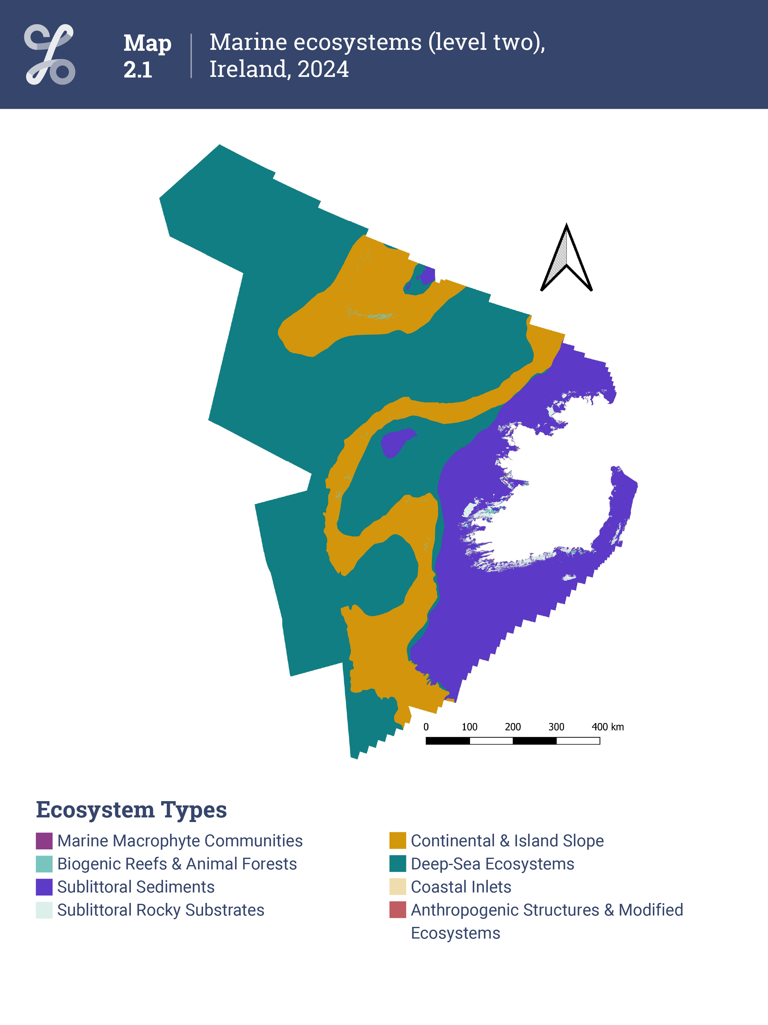
Map 2.1 Marine ecosystems (level two), Ireland, 2024
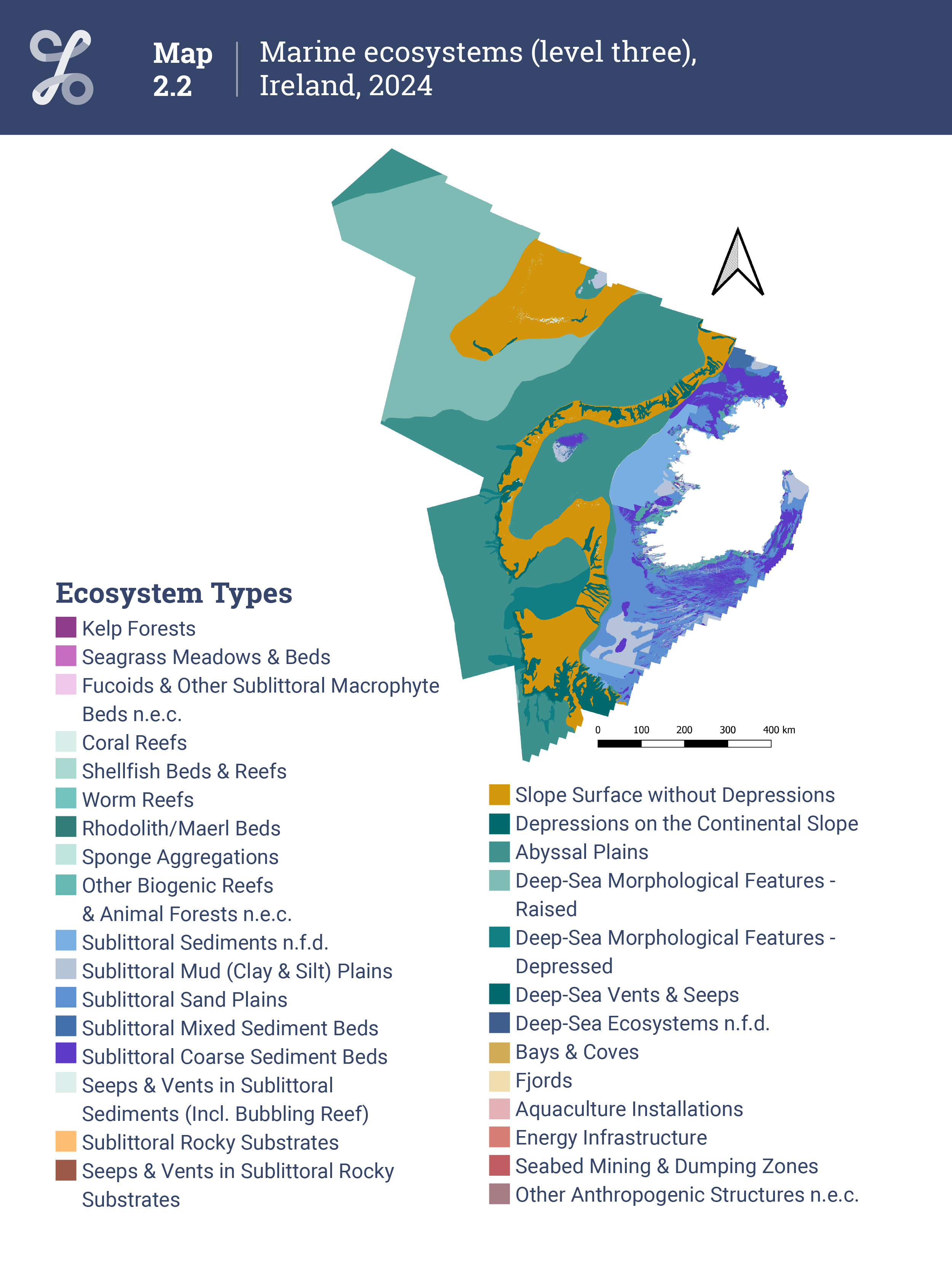
Map 2.2 Marine ecosystems (level three), Ireland, 2024
Looking in more detail at different types of marine ecosystems, Kelp Forests make up the majority (90.3%) of the Marine Macrophyte Community ecosystem, at 36,500 hectares, with Seagrass Meadows & Beds covering 1,800 hectares (4.5%), and Fucoids & Other Sublittoral Macrophyte Beds n.e.c. covering 2,100 hectares (5.2%), see Table 2.2, Map 2.2.
Of the Biogenic Reefs & Animal Forests, Coral Reefs make up almost half (46%), at 70,200 hectares, while a similar area (71,500 hectares) was classified as Other Biogenic Reefs & Animal Forests n.e.c.. The remainder of this class was made up of Shellfish Beds & Reefs (1,500 hectares), Worm Reefs (800 hectares), Rhodolith/Maerl Beds (7,700 hectares) and Sponge Aggregations (900 hectares).
Sublittoral Sediments were mostly made up of Sublittoral Sand Plains (5.6 million hectares; 39.3%), Sublittoral Coarse Sediment Beds (3.7 million hectares; 26.1%), Sublittoral Mud (Clay & Silt) Plains (1.9 million hectares; 13.6%), and Sublittoral Sediments n.f.d. (2.5 million hectares; 17.9%).
Of the Sublittoral Rocky Substrates ecosystem, almost all of this ecosystem type at level 2 was also of the same type at level 3, with just 100 hectares classed as Seeps & Vents in Sublittoral Rocky Substrates.
The Continental & Island Slope ecosystem was composed mostly of Slope Surface without Depressions (12.3 million hectares; 81.1%), with the remainder made up of Depressions on the Continental Slope (2.9 million hectares; 18.9%).
Deep-Sea Ecosystems, which covered the largest area overall, mostly comprised Abyssal Plains (24.1 million hectares; 58.5%) and Deep-Sea Morphological Features - Raised (15.3 million hectares; 37%), with Deep-Sea Morphological Features - Depressed covering 1.8 million hectares (4.4%). Deep-Sea Vents & Seeps and Deep-Sea Ecosystems n.f.d. were both present but covered very small areas (less than 50 hectares).
The Coastal Inlets ecosystem was composed of Bays & Coves (2,800 hectares) and Fjords (200 hectares), but note that this is the area of these types of water bodies not already mapped as ecosystem types 12.8, 12.1, 12.2, 12.3, or 12.4 (see Background Notes for more information on how the classification was applied).
Of the Anthropogenic Structures & Modified Ecosystems, Aquaculture Installations covered 6,400 hectares (53.3%), Seabed Mining & Dumping Zones covered 3,900 hectares (32.5%), Other Anthropogenic Structures n.e.c. (including shipwrecks) covered 1,300 hectares (10.8%), and Energy Infrastructure covered 500 hectares (4.2%).
Learn about our data and confidentiality safeguards, and the steps we take to produce statistics that can be trusted by all.