
| Number of Dwelling Units | |||
| Houses | Apartments | Totals | |
| Quarter 3 2015 | 2,345 | 359 | 2,704 |
| Quarter 3 2016 | 4,362 | 1,452 | 5,814 |
| % change | 86.0% | 304.5% | 115.0% |
| X-axis label | Planning Permissions Civil | Planning Permissions Non-Res | Planning Permissions Dwellings |
|---|---|---|---|
| 2011 | 689 | 3655 | 10586 |
| 2012 | 821 | 3794 | 8569 |
| 2013 | 806 | 3440 | 8204 |
| 2014 | 1232 | 3498 | 9072 |
| 2015 | 1519 | 4085 | 9845 |
| Table A Summary of Planning Permissions granted for new Dwelling Units | ||||||||||||
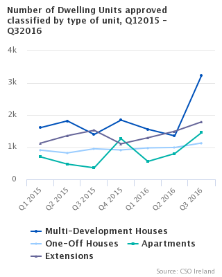
| Period | All Houses | Annual % change | of which Multi-Development Houses | Annual % change | of which One-off houses | Annual % change | Apartments | Annual % change | Total Dwellings (All Houses & Apartments) | Annual % change | ||
| 2014 | Q1 | 1,446 | -22% | 672 | -38% | 774 | 0% | 158 | -65% | 1,604 | -31% | |
| Q2 | 1,492 | -0% | 740 | -9% | 752 | 10% | 114 | -73% | 1,606 | -17% | ||
| Q3 | 1,783 | 42% | 962 | 122% | 821 | 0% | 361 | 130% | 2,144 | 52% | ||
| Q4 | 1,905 | 37% | 1,156 | 53% | 749 | 17% | 152 | -6% | 2,057 | 32% | ||
| Year | 6,626 | 10% | 3,530 | 14% | 3,096 | 6% | 785 | -34% | 7,411 | 3% | ||
| 2015 | Q1 | 2,514 | 74% | 1,606 | 139% | 908 | 17% | 699 | 342% | 3,213 | 100% | |
| Q2 | 2,637 | 77% | 1,816 | 145% | 821 | 9% | 473 | 315% | 3,110 | 94% | ||
| Q3 | 2,345 | 32% | 1,395 | 45% | 950 | 16% | 359 | -1% | 2,704 | 26% | ||
| Q4 | 2,754 | 45% | 1,841 | 59% | 913 | 22% | 1,263 | 731% | 4,017 | 95% | ||
| Year | 10,250 | 55% | 6,658 | 89% | 3,592 | 16% | 2,794 | 256% | 13,044 | 76% | ||
| 2016 | Q1 | 2,534 | 1% | 1,556 | -3% | 978 | 8% | 557 | -20% | 3,091 | -4% | |
| Q2 | 2,340 | -11% | 1,350 | -26% | 990 | 21% | 801 | 69% | 3,141 | 1% | ||
| Q3 | 4,362 | 86% | 3,233 | 132% | 1,129 | 19% | 1,452 | 305% | 5,814 | 115% | ||
| Note: Percentages are rounded for tabular purposes | ||||||||||||
| Table 1 Summary of Planning Permissions granted, Q1 2008 - Q3 2016 | ||||||||||||||||||||||||||
| Number of Permissions | Total Floor Area (000 sq.m ) | |||||||||||||||||||||||||
| New Construction | Extension | Alteration and Conversion | Total | New Construction | Extension | Total1 | ||||||||||||||||||||
| Period | Dwellings | Other | Dwellings | Other | ||||||||||||||||||||||
| 2008 | Q 1 | 4,777 | 2,104 | 3,523 | 651 | 11,055 | 2,645 | 1,359 | 509 | 4,514 | ||||||||||||||||
| Q 2 | 4,722 | 2,050 | 3,743 | 700 | 11,215 | 2,901 | 1,425 | 444 | 4,770 | |||||||||||||||||
| Q 3 | 4,253 | 1,774 | 4,166 | 711 | 10,904 | 2,263 | 1,265 | 470 | 3,998 | |||||||||||||||||
| Q 4 | 3,739 | 1,616 | 3,003 | 619 | 8,977 | 2,028 | 1,102 | 387 | 3,517 | |||||||||||||||||
| Year | 17,491 | 7,544 | 14,435 | 2,681 | 42,151 | 9,837 | 5,151 | 1,810 | 16,799 | |||||||||||||||||
| 2009 | Q 1 | 3,275 | 1,231 | 2,499 | 481 | 7,486 | 2,090 | 870 | 459 | 3,419 | ||||||||||||||||
| Q 2 | 2,689 | 1,158 | 2,405 | 504 | 6,756 | 1,753 | 872 | 281 | 2,906 | |||||||||||||||||
| Q 3 | 2,505 | 1,218 | 2,433 | 499 | 6,655 | 1,273 | 915 | 278 | 2,466 | |||||||||||||||||
| Q 4 | 1,911 | 908 | 1,885 | 433 | 5,137 | 812 | 408 | 179 | 1,399 | |||||||||||||||||
| Year | 10,380 | 4,515 | 9,222 | 1,917 | 26,034 | 5,928 | 3,065 | 1,197 | 10,190 | |||||||||||||||||
| 2010 | Q 1 | 1,768 | 775 | 1,617 | 359 | 4,519 | 844 | 303 | 181 | 1,328 | ||||||||||||||||
| Q 2 | 1,513 | 772 | 1,996 | 394 | 4,675 | 776 | 553 | 232 | 1,561 | |||||||||||||||||
| Q 3 | 1,634 | 866 | 2,319 | 453 | 5,272 | 727 | 415 | 271 | 1,412 | |||||||||||||||||
| Q 4 | 1,432 | 792 | 1,778 | 371 | 4,373 | 514 | 254 | 186 | 955 | |||||||||||||||||
| Year | 6,347 | 3,205 | 7,710 | 1,577 | 18,839 | 2,861 | 1,525 | 870 | 5,256 | |||||||||||||||||
| 2011 | Q 1 | 1,277 | 700 | 1,637 | 405 | 4,019 | 599 | 376 | 202 | 1,177 | ||||||||||||||||
| Q 2 | 1,264 | 721 | 1,866 | 393 | 4,244 | 560 | 452 | 209 | 1,222 | |||||||||||||||||
| Q 3 | 1,271 | 862 | 1,896 | 417 | 4,446 | 465 | 288 | 216 | 969 | |||||||||||||||||
| Q 4 | 955 | 681 | 1,312 | 335 | 3,283 | 357 | 214 | 137 | 708 | |||||||||||||||||
| Year | 4,767 | 2,964 | 6,711 | 1,550 | 15,992 | 1,982 | 1,330 | 765 | 4,077 | |||||||||||||||||
| 2012 | Q 1 | 957 | 695 | 1,339 | 377 | 3,368 | 279 | 283 | 173 | 734 | ||||||||||||||||
| Q 2 | 942 | 828 | 1,549 | 353 | 3,672 | 284 | 341 | 199 | 824 | |||||||||||||||||
| Q 3 | 907 | 1,050 | 1,680 | 410 | 4,047 | 312 | 346 | 219 | 877 | |||||||||||||||||
| Q 4 | 837 | 834 | 1,341 | 308 | 3,320 | 325 | 261 | 177 | 763 | |||||||||||||||||
| Year | 3,643 | 3,407 | 5,909 | 1,448 | 14,407 | 1,199 | 1,231 | 768 | 3,198 | |||||||||||||||||
| 2013 | Q 1 | 862 | 785 | 1,296 | 332 | 3,275 | 394 | 366 | 169 | 930 | ||||||||||||||||
| Q 2 | 772 | 754 | 1,489 | 353 | 3,368 | 333 | 331 | 170 | 834 | |||||||||||||||||
| Q 3 | 931 | 904 | 1,665 | 375 | 3,875 | 282 | 312 | 229 | 823 | |||||||||||||||||
| Q 4 | 751 | 988 | 1,245 | 399 | 3,383 | 295 | 297 | 159 | 751 | |||||||||||||||||
| Year | 3,316 | 3,431 | 5,695 | 1,459 | 13,901 | 1,305 | 1,306 | 727 | 3,338 | |||||||||||||||||
| 2014 | Q 1 | 891 | 1,006 | 1,396 | 540 | 3,833 | 336 | 229 | 180 | 744 | ||||||||||||||||
| Q 2 | 875 | 1,091 | 1,590 | 593 | 4,149 | 296 | 242 | 174 | 712 | |||||||||||||||||
| Q 3 | 962 | 1,183 | 1,705 | 478 | 4,328 | 366 | 379 | 228 | 974 | |||||||||||||||||
| Q 4 | 878 | 1,019 | 1,261 | 346 | 3,504 | 368 | 214 | 172 | 754 | |||||||||||||||||
| Year | 3,606 | 4,299 | 5,952 | 1,957 | 15,814 | 1,366 | 1,064 | 754 | 3,184 | |||||||||||||||||
| 2015 | Q 1 | 1,066 | 1,046 | 1,454 | 335 | 3,901 | 525 | 243 | 206 | 973 | ||||||||||||||||
| Q 2 | 991 | 1,021 | 1,663 | 372 | 4,047 | 527 | 321 | 216 | 1,065 | |||||||||||||||||
| Q 3 | 1,128 | 1,492 | 1,942 | 447 | 5,009 | 494 | 568 | 293 | 1,354 | |||||||||||||||||
| Q 4 | 1,084 | 1,565 | 1,413 | 408 | 4,470 | 601 | 687 | 180 | 1,468 | |||||||||||||||||
| Year | 4,269 | 5,124 | 6,472 | 1,562 | 17,427 | 2,147 | 1,819 | 895 | 4,861 | |||||||||||||||||
| 2016 | Q 1 | 1,169 | 1,695 | 1,680 | 370 | 4,914 | 502 | 522 | 256 | 1,280 | ||||||||||||||||
| Q 2 | 1,203 | 1,758 | 1,849 | 426 | 5,236 | 554 | 460 | 231 | 1,245 | |||||||||||||||||
| Q 3 | 1,403 | 1,974 | 2,198 | 551 | 6,126 | 845 | 629 | 262 | 1,736 | |||||||||||||||||
| 1 For categories where floor area is a relevant measure | ||||||||||||||||||||||||||
| Table 2 Summary of Planning Permissions granted, Q3 2016, classified by region, county and type of development | ||||||||||
| Planning Region and County | Number of Permissions | Total Floor Area (000 sq.m) | ||||||||
| New Construction | Extension | Alteration and Conversion | Total | New Construction | Extension | Total1 | ||||
| Dwellings | Other | Dwellings | Other | |||||||
| Border, Midland and West | ||||||||||
| 457 | 611 | 528 | 150 | 1,746 | 176 | 162 | 85 | 422 | ||
| Border | 201 | 262 | 219 | 73 | 755 | 69 | 98 | 35 | 201 | |
| Cavan | 21 | 35 | 33 | 1 | 90 | 6 | 16 | 9 | 32 | |
| Donegal | 76 | 77 | 78 | 21 | 252 | 21 | 18 | 7 | 46 | |
| Leitrim | 1 | 22 | 13 | 3 | 39 | 0 | 4 | 1 | 5 | |
| Louth | 36 | 33 | 48 | 22 | 139 | 20 | 7 | 9 | 36 | |
| Monaghan | 34 | 60 | 23 | 14 | 131 | 9 | 47 | 5 | 60 | |
| Sligo | 33 | 35 | 24 | 12 | 104 | 13 | 6 | 4 | 22 | |
| Midland | 105 | 174 | 92 | 21 | 392 | 43 | 35 | 11 | 89 | |
| Laois | 33 | 58 | 26 | 4 | 121 | 18 | 16 | 2 | 36 | |
| Longford | 12 | 44 | 12 | 3 | 71 | 3 | 7 | 1 | 11 | |
| Offaly | 17 | 37 | 22 | 3 | 79 | 4 | 4 | 5 | 13 | |
| Westmeath | 43 | 35 | 32 | 11 | 121 | 18 | 8 | 3 | 29 | |
| West | 151 | 175 | 217 | 56 | 599 | 65 | 29 | 38 | 132 | |
| Galway City | 11 | 10 | 35 | 24 | 80 | 9 | 0 | 8 | 17 | |
| Galway2 | 66 | 95 | 91 | 19 | 271 | 24 | 19 | 17 | 61 | |
| Mayo | 55 | 24 | 63 | 12 | 154 | 19 | 4 | 10 | 33 | |
| Roscommon | 19 | 46 | 28 | 1 | 94 | 12 | 5 | 3 | 21 | |
| Southern and Eastern | 946 | 1,363 | 1,670 | 401 | 4,380 | 669 | 468 | 177 | 1,314 | |
| Dublin | 186 | 297 | 626 | 160 | 1,269 | 291 | 196 | 50 | 537 | |
| Dublin City | 82 | 146 | 251 | 89 | 568 | 142 | 72 | 23 | 237 | |
| Dun Laoghaire-Rathdown | 40 | 56 | 158 | 36 | 290 | 65 | 83 | 10 | 157 | |
| Fingal | 52 | 48 | 123 | 14 | 237 | 63 | 7 | 12 | 83 | |
| South Dublin | 12 | 47 | 94 | 21 | 174 | 21 | 34 | 5 | 60 | |
| Mid-East | 174 | 171 | 236 | 51 | 632 | 168 | 51 | 27 | 246 | |
| Kildare | 45 | 61 | 82 | 13 | 201 | 65 | 25 | 9 | 99 | |
| Meath | 81 | 63 | 83 | 22 | 249 | 73 | 19 | 11 | 104 | |
| Wicklow | 48 | 47 | 71 | 16 | 182 | 30 | 6 | 7 | 43 | |
| Mid-West | 113 | 179 | 154 | 34 | 480 | 54 | 40 | 24 | 118 | |
| Clare | 48 | 70 | 70 | 7 | 195 | 26 | 16 | 7 | 49 | |
| Limerick | 40 | 53 | 53 | 19 | 165 | 16 | 15 | 5 | 37 | |
| North Tipperary | 25 | 56 | 31 | 8 | 120 | 11 | 8 | 12 | 31 | |
| South-East | 162 | 300 | 237 | 63 | 762 | 44 | 68 | 31 | 143 | |
| Carlow | 13 | 28 | 30 | 9 | 80 | 3 | 3 | 4 | 10 | |
| Kilkenny | 31 | 68 | 49 | 11 | 159 | 8 | 10 | 5 | 22 | |
| South Tipperary | 19 | 59 | 34 | 9 | 121 | 4 | 15 | 6 | 26 | |
| Waterford | 30 | 69 | 58 | 13 | 170 | 12 | 19 | 9 | 41 | |
| Wexford | 69 | 76 | 66 | 21 | 232 | 16 | 21 | 6 | 43 | |
| South-West | 311 | 416 | 417 | 93 | 1,237 | 112 | 114 | 45 | 271 | |
| Cork City | 26 | 30 | 52 | 15 | 123 | 12 | 0 | 4 | 16 | |
| Cork2 | 232 | 311 | 288 | 67 | 898 | 80 | 99 | 36 | 215 | |
| Kerry | 53 | 75 | 77 | 11 | 216 | 20 | 15 | 5 | 41 | |
| State | 1,403 | 1,974 | 2,198 | 551 | 6,126 | 845 | 629 | 262 | 1,736 | |
| 1 For categories where floor area is a relevant measure | ||||||||||
| 2 Excluding cities | ||||||||||
| - No permissions | ||||||||||
| Note: 0 implies less than 500sq m | ||||||||||
| Table 3(a) Number of Planning Permissions granted, Q3 2016, classified by region, type of development and functional category | |||||||||
| Functional Category | |||||||||
| Type of Development and Planning Region | Dwellings | Commercial Buildings | Buildings for Agriculture | Industrial Buildings | Govt., Health and Education | Other Buildings for Social Use | Civil Eng. | Other | Total |
| New Construction | |||||||||
| Border, Midland and Western | 457 | 20 | 214 | 17 | 14 | 4 | 161 | 181 | 1,068 |
| Border | 201 | 11 | 95 | 9 | 8 | 1 | 68 | 70 | 463 |
| Midland | 105 | 7 | 51 | 6 | 2 | 2 | 62 | 44 | 279 |
| West | 151 | 2 | 68 | 2 | 4 | 1 | 31 | 67 | 326 |
| Southern and Eastern | 946 | 74 | 280 | 56 | 27 | 19 | 365 | 542 | 2,309 |
| Dublin | 186 | 40 | 4 | 16 | 9 | 4 | 39 | 185 | 483 |
| Mid-East | 174 | 12 | 30 | 2 | 7 | 4 | 47 | 69 | 345 |
| Mid-West | 113 | 3 | 55 | 8 | 2 | 2 | 44 | 65 | 292 |
| South-East | 162 | 10 | 84 | 13 | 3 | 5 | 91 | 94 | 462 |
| South West | 311 | 9 | 107 | 17 | 6 | 4 | 144 | 129 | 727 |
| State | 1,403 | 94 | 494 | 73 | 41 | 23 | 526 | 723 | 3,377 |
| Extension | |||||||||
| Border, Midland and Western | 383 | 30 | 25 | 17 | 57 | 16 | - | - | 528 |
| Border | 161 | 13 | 14 | 10 | 15 | 6 | - | - | 219 |
| Midland | 77 | 4 | 2 | 3 | 6 | - | - | - | 92 |
| West | 145 | 13 | 9 | 4 | 36 | 10 | - | - | 217 |
| Southern and Eastern | 1,403 | 78 | 44 | 32 | 80 | 33 | - | - | 1,670 |
| Dublin | 557 | 31 | - | 6 | 23 | 9 | - | - | 626 |
| Mid-East | 196 | 8 | 3 | 3 | 17 | 9 | - | - | 236 |
| Mid-West | 124 | 11 | 4 | 6 | 7 | 2 | - | - | 154 |
| South-East | 180 | 12 | 21 | 5 | 13 | 6 | - | - | 237 |
| South West | 346 | 16 | 16 | 12 | 20 | 7 | - | - | 417 |
| State | 1,786 | 108 | 69 | 49 | 137 | 49 | - | - | 2,198 |
| Alteration and Conversion | |||||||||
| Border, Midland and Western | 37 | 62 | 5 | 8 | 28 | 10 | - | - | 150 |
| Border | 12 | 37 | 2 | 1 | 15 | 6 | - | - | 73 |
| Midland | 4 | 7 | 2 | 2 | 4 | 2 | - | - | 21 |
| West | 21 | 18 | 1 | 5 | 9 | 2 | - | - | 56 |
| Southern and Eastern | 152 | 149 | 4 | 18 | 49 | 29 | - | - | 401 |
| Dublin | 73 | 59 | - | 8 | 13 | 7 | - | - | 160 |
| Mid-East | 15 | 16 | 1 | 2 | 9 | 8 | - | - | 51 |
| Mid-West | 5 | 15 | 2 | 3 | 4 | 5 | - | - | 34 |
| South-East | 9 | 34 | 1 | 1 | 13 | 5 | - | - | 63 |
| South West | 50 | 25 | - | 4 | 10 | 4 | - | - | 93 |
| State | 189 | 211 | 9 | 26 | 77 | 39 | - | - | 551 |
| All Developments | |||||||||
| Border, Midland and Western | 877 | 112 | 244 | 42 | 99 | 30 | 161 | 181 | 1,746 |
| Border | 374 | 61 | 111 | 20 | 38 | 13 | 68 | 70 | 755 |
| Midland | 186 | 18 | 55 | 11 | 12 | 4 | 62 | 44 | 392 |
| West | 317 | 33 | 78 | 11 | 49 | 13 | 31 | 67 | 599 |
| Southern and Eastern | 2,501 | 301 | 328 | 106 | 156 | 81 | 365 | 542 | 4,380 |
| Dublin | 816 | 130 | 4 | 30 | 45 | 20 | 39 | 185 | 1,269 |
| Mid-East | 385 | 36 | 34 | 7 | 33 | 21 | 47 | 69 | 632 |
| Mid-West | 242 | 29 | 61 | 17 | 13 | 9 | 44 | 65 | 480 |
| South-East | 351 | 56 | 106 | 19 | 29 | 16 | 91 | 94 | 762 |
| South West | 707 | 50 | 123 | 33 | 36 | 15 | 144 | 129 | 1,237 |
| State | 3,378 | 413 | 572 | 148 | 255 | 111 | 526 | 723 | 6,126 |
| - No permissions | |||||||||
| Table 3(b) Total Floor Area Planned (000 sq.m) in new construction and extensions, Q3 2016, classified by region and functional category | |||||||
| Functional Category | |||||||
| Type of Development and Planning Region | Dwellings | Commercial Buildings | Buildings for Agriculture | Industrial Buildings | Govt., Health and Education | Other Buildings for Social Use | Total1 |
| New Construction | |||||||
| Border, Midland and Western | 176 | 10 | 118 | 15 | 16 | 2 | 338 |
| Border | 69 | 5 | 67 | 14 | 11 | 0 | 166 |
| Midland | 43 | 3 | 28 | 1 | 0 | 2 | 78 |
| West | 65 | 1 | 23 | 0 | 4 | 0 | 93 |
| Southern and Eastern | 669 | 185 | 160 | 52 | 47 | 24 | 1,137 |
| Dublin | 291 | 157 | 2 | 29 | 7 | 1 | 487 |
| Mid-East | 168 | 5 | 22 | 1 | 11 | 12 | 219 |
| Mid-West | 54 | 6 | 23 | 9 | 3 | 1 | 94 |
| South-East | 44 | 6 | 46 | 5 | 9 | 2 | 112 |
| South West | 112 | 12 | 68 | 8 | 18 | 9 | 226 |
| State | 845 | 195 | 278 | 67 | 63 | 26 | 1,475 |
| Extension | |||||||
| Border, Midland and Western | 26 | 13 | 8 | 13 | 21 | 3 | 85 |
| Border | 11 | 3 | 5 | 10 | 5 | 1 | 35 |
| Midland | 6 | 1 | 1 | 2 | 2 | - | 11 |
| West | 10 | 9 | 2 | 2 | 14 | 2 | 38 |
| Southern and Eastern | 79 | 17 | 15 | 28 | 32 | 6 | 177 |
| Dublin | 25 | 7 | - | 1 | 15 | 3 | 50 |
| Mid-East | 13 | 2 | 0 | 2 | 7 | 2 | 27 |
| Mid-West | 9 | 3 | 1 | 10 | 1 | 1 | 24 |
| South-East | 11 | 2 | 6 | 6 | 6 | 0 | 31 |
| South West | 21 | 4 | 8 | 9 | 3 | 0 | 45 |
| State | 106 | 30 | 23 | 41 | 52 | 10 | 262 |
| Total New Construction and Extension | |||||||
| Border, Midland and Western | 202 | 23 | 126 | 29 | 36 | 6 | 422 |
| Border | 79 | 9 | 72 | 24 | 16 | 2 | 201 |
| Midland | 49 | 4 | 29 | 3 | 2 | 2 | 89 |
| West | 74 | 10 | 25 | 2 | 18 | 2 | 132 |
| Southern and Eastern | 748 | 202 | 175 | 79 | 79 | 30 | 1,314 |
| Dublin | 316 | 163 | 2 | 31 | 21 | 4 | 537 |
| Mid-East | 182 | 7 | 22 | 3 | 18 | 14 | 246 |
| Mid-West | 63 | 8 | 24 | 18 | 4 | 1 | 118 |
| South-East | 55 | 8 | 51 | 11 | 15 | 2 | 143 |
| South West | 133 | 16 | 76 | 17 | 21 | 9 | 271 |
| State | 951 | 225 | 301 | 108 | 115 | 36 | 1,736 |
| 1 For categories where floor area is a relevant measure | |||||||
| - No Permission | |||||||
| Note: 0 implies less than 500sq m | |||||||
| Table 4 Summary of Planning Permissions Granted for new houses and apartments, Q1 2011 - Q3 2016 | |||||||||||||||||
| All Houses | of which Multi-Development Houses | of which One-Off Houses | Apartments | ||||||||||||||
| Number of Permissions | Number of Units | Floor Area (000 m2) | Average Floor Area per Unit (m2) | Number of Permissions | Number of Units | Floor Area (000 m2) | Average Floor Area per Unit (m2) | Number of Permissions | Number of Units | Floor Area (000 m2) | Average Floor Area per Unit (m2) | Number of Permissions | Number of Units | Floor Area (000 m2) | Average Floor Area per Unit (m2) | ||
| 2011 | Q 1 | 1,205 | 3,075 | 528 | 171.7 | 78 | 1,948 | 246 | 126.2 | 1,127 | 1,127 | 282 | 250.3 | 67 | 592 | 65 | 109.2 |
| Q 2 | 1,197 | 2,599 | 487 | 187.3 | 71 | 1,473 | 204 | 138.8 | 1,126 | 1,126 | 282 | 250.7 | 63 | 711 | 70 | 98.9 | |
| Q 3 | 1,207 | 1,887 | 389 | 206.4 | 83 | 763 | 111 | 145.9 | 1,124 | 1,124 | 278 | 247.5 | 56 | 625 | 73 | 117.5 | |
| Q 4 | 907 | 1,537 | 302 | 196.3 | 41 | 671 | 86 | 128.6 | 866 | 866 | 210 | 249.0 | 43 | 619 | 54 | 87.9 | |
| Year | 4,516 | 9,098 | 1,706 | 187.5 | 273 | 4,855 | 647 | 133.4 | 4,243 | 4,243 | 1,058 | 249.4 | 229 | 2,547 | 263 | 103.2 | |
| 2012 | Q 1 | 902 | 1,263 | 268 | 212.4 | 34 | 395 | 53 | 134.7 | 868 | 868 | 215 | 247.8 | 49 | 92 | 7 | 80.8 |
| Q 2 | 875 | 1,166 | 257 | 220.0 | 45 | 336 | 48 | 143.2 | 830 | 830 | 208 | 251.2 | 62 | 240 | 24 | 101.8 | |
| Q 3 | 857 | 1,540 | 302 | 196.1 | 56 | 739 | 107 | 145.4 | 801 | 801 | 194 | 242.8 | 47 | 98 | 8 | 85.1 | |
| Q 4 | 788 | 1,420 | 283 | 199.4 | 37 | 669 | 96 | 143.2 | 751 | 751 | 187 | 249.5 | 46 | 431 | 40 | 92.5 | |
| Year | 3,422 | 5,389 | 1,110 | 206.0 | 172 | 2,139 | 305 | 142.4 | 3,250 | 3,250 | 805 | 247.8 | 204 | 861 | 80 | 93.0 | |
| 2013 | Q 1 | 818 | 1,860 | 345 | 185.7 | 45 | 1,087 | 155 | 142.6 | 773 | 773 | 190 | 246.2 | 40 | 448 | 46 | 102.1 |
| Q 2 | 727 | 1,496 | 280 | 187.1 | 43 | 812 | 109 | 134.5 | 684 | 684 | 171 | 249.6 | 40 | 430 | 50 | 116.9 | |
| Q 3 | 864 | 1,252 | 266 | 212.6 | 45 | 433 | 63 | 146.6 | 819 | 819 | 203 | 247.5 | 64 | 157 | 12 | 76.6 | |
| Q 4 | 694 | 1,394 | 270 | 193.6 | 54 | 754 | 109 | 144.1 | 640 | 640 | 161 | 252.0 | 53 | 162 | 15 | 93.6 | |
| Year | 3,103 | 6,002 | 1,161 | 193.5 | 187 | 3,086 | 436 | 141.4 | 2,916 | 2,916 | 725 | 248.6 | 197 | 1,197 | 123 | 103.0 | |
| 2014 | Q 1 | 835 | 1,446 | 296 | 204.6 | 61 | 672 | 106 | 157.3 | 774 | 774 | 190 | 245.7 | 49 | 158 | 15 | 96.9 |
| Q 2 | 809 | 1,492 | 283 | 190.0 | 57 | 740 | 99 | 133.2 | 752 | 752 | 185 | 245.9 | 63 | 114 | 10 | 84.9 | |
| Q 3 | 887 | 1,783 | 330 | 185.2 | 66 | 962 | 134 | 138.9 | 821 | 821 | 197 | 239.6 | 65 | 361 | 31 | 86.9 | |
| Q 4 | 804 | 1,905 | 352 | 184.5 | 55 | 1,156 | 166 | 143.2 | 749 | 749 | 186 | 248.3 | 69 | 152 | 13 | 85.3 | |
| Year | 3,335 | 6,626 | 1,261 | 190.3 | 239 | 3,530 | 503 | 142.6 | 3,096 | 3,096 | 758 | 244.8 | 246 | 785 | 69 | 88.3 | |
| 2015 | Q 1 | 977 | 2,514 | 454 | 180.6 | 69 | 1,606 | 232 | 144.3 | 908 | 908 | 222 | 244.8 | 82 | 699 | 68 | 97.2 |
| Q 2 | 913 | 2,637 | 475 | 180.0 | 92 | 1,816 | 277 | 152.5 | 821 | 821 | 198 | 241.0 | 73 | 473 | 47 | 99.7 | |
| Q 3 | 1,036 | 2,345 | 419 | 178.6 | 86 | 1,395 | 189 | 135.2 | 950 | 950 | 230 | 242.4 | 85 | 359 | 32 | 89.2 | |
| Q 4 | 995 | 2,754 | 481 | 174.7 | 82 | 1,841 | 259 | 140.5 | 913 | 913 | 222 | 243.5 | 86 | 1,263 | 119 | 94.2 | |
| Year | 3,921 | 10,250 | 1,829 | 178.4 | 329 | 6,658 | 956 | 143.6 | 3,592 | 3,592 | 873 | 243.0 | 326 | 2,794 | 266 | 95.2 | |
| 2016 | Q 1 | 1,072 | 2,534 | 445 | 175.7 | 94 | 1,556 | 209 | 134.2 | 978 | 978 | 236 | 241.8 | 90 | 557 | 50 | 90.1 |
| Q 2 | 1,090 | 2,340 | 422 | 180.3 | 100 | 1,350 | 188 | 139.0 | 990 | 990 | 234 | 236.6 | 107 | 801 | 71 | 88.0 | |
| Q 3 | 1,273 | 4,362 | 703 | 161.1 | 144 | 3,233 | 434 | 134.2 | 1,129 | 1,129 | 269 | 238.4 | 126 | 1,452 | 126 | 87.0 | |
Details of the scope and background of this series were given in the March 1973 Statistical Bulletin. The Planning and Development Acts 1963 - 2000, imposes certain requirements on builders, developers and all other persons who propose to build or develop and specifies that a planning permission must be obtained from the relevant Planning Authority.
Local authority building (including housing) is exempt in the case where construction takes place in the Authorities’ own area. Therefore, works undertaken by a local authority outside its functional area come within the scope of the Acts, and need planning permission. Planning permission is also needed for development by the State, except where the consultation procedures provided for in the Local Government (Planning and Development) Act, 1993 obtain (e.g. national security, public safety or order, the administration of justice etc). This series only provides coverage where development is subject to the requirement to obtain planning permission.
This series is also available using the interactive tables in StatBank on the CSO website.
The Local Government Act 1991 (Regional Authorities) (Establishment) Order, 1993, which came into operation on 1 January 1994, established eight new Regions. The CSO has adopted these in place of the old Planning Regions as the basis for the regional breakdown of planning permissions data.
Planning permissions are classified by type of development, local authority district and by regional authority. A distinction is made between residential and non-residential building and civil engineering.
Only final grants of permission or approvals are covered, i.e. only works which involve construction. The following permissions are excluded since they do not entail construction per se:
As the figures for floor area have been rounded there may be slight discrepancies between the sum of the constituent items and the totals shown.
Estimates are included where complete details of floor area size are not available.
The regional classifications in this release are based on the NUTS (Nomenclature of Territorial Units) classification used by Eurostat. The NUTS3 regions correspond to the eight Regional Authorities established under the Local Government Act, 1991 (Regional Authorities) (Establishment) Order, 1993, which came into operation on 1 January 1994. The NUTS2 regions, which were proposed by Government and agreed by Eurostat in 1999, are groupings of the NUTS3 regions. The composition of the regions is set out below.
|
Border Midlands and Western NUTS 2 Region |
Eastern and Southern NUTS 2 Region |
|||
| Border | Cavan |
|
Dublin | Dublin |
| Donegal | Dun Laoghaire - Rathdown | |||
| Leitrim | Fingal | |||
| Louth | South Dubin | |||
| Monaghan | ||||
| Sligo | ||||
| Midland | Laois | Mid-East | Kildare | |
| Longford | Meath | |||
| Offaly | Wicklow | |||
| Westmeath | ||||
| West | Galway City | South-West | Cork City | |
| Galway County | Cork County | |||
| Mayo | Kerry | |||
| Roscommon | ||||
| South-East | Carlow | |||
| Kilkenny | ||||
| South Tipperary | ||||
| Waterford | ||||
| Wexford | ||||
| Mid -West | Clare | |||
| Limerick | ||||
| North Tipperary |
 Hide Background Notes
Scan the QR code below to view this release online or go to
http://www.cso.ie/en/releasesandpublications/er/pp/planningpermissionsquarter32016/
 Show Table A Summary of Planning Permissions granted for new Dwelling Units
 Hide Table A Summary of Planning Permissions granted for new Dwelling Units