

The CSO, through Ireland's Institute for SDGs (IIS), supports reporting on the Sustainable Development Goals.
SDG 14.5.1 Coverage of Protected Areas in Relation to Marine Areas
SDG 14.6.1 Degree of Implementation of International Instruments Aiming to Combat Illegal, Unreported and Unregulated Fishing
SDG 14.7.1 Sustainable Fisheries as a Proportion of GDP in Small Island Developing States, Least Developed Countries and all Countries
SDG 14.5.1 Coverage of protected areas in relation to marine areas is published by the Department of Housing, Local Government and Heritage.
The report Expanding Ireland’s Marine Protected Area Network, is published by the Department of Housing, Local Government and Heritage. This report defines Marine Protected Areas (MPAs) as marine areas that are protected and managed over the long term, with a primary objective of conserving habitats and/or species.
Key messages from this report include:
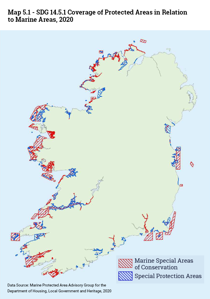
Map 5.1 shows Ireland’s Special Areas of Conservation (SACs) in red and Special Protection Areas (SPAs) in blue, designated for marine features and clipped at the mean high water line to show only the maritime component of these sites.
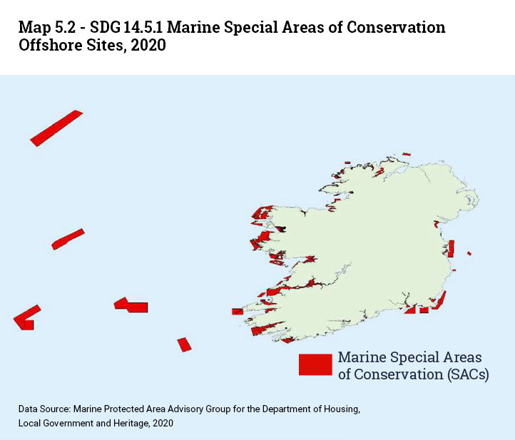
Offshore sites are not shown to allow coastal detail to be seen and are instead included in Map 5.2.
The indicator measures the surface of MPAs in EU marine waters. The indicator comprises nationally designated protected areas and Natura 2000 sites. A nationally designated area is an area protected by national legislation. The Natura 2000 network comprises both marine and terrestrial protected areas designated under the EU Habitats and Birds Directives with the goal to maintain or restore a favourable conservation status for habitat types and species of EU interest.
Data on surface of the marine protected areas is on the Eurostat SDG database, as shown in Table 5.1.
Information on Marine Protected Areas (MPAs) is available in the 2018 Status Report on the OSPAR Network of Marine Protected Areas.
The distribution of OSPAR MPAs across the five OSPAR regions, i.e. Arctic Waters (Region I), Greater North Sea (Region II), Celtic Seas (Region III), Bay of Biscay and Iberian Coast (Region IV) and Wider Atlantic (Region V), is shown in Table 5.2.
The Greater North Sea (OSPAR Region II) has the most bordering Contracting Parties of all OSPAR regions and all have contributed MPAs to the network. The MPAs nominated by Belgium, Denmark, France, Germany, the Netherlands, Norway, Sweden and the United Kingdom cover 18.6 % (142,489 Km2) of the Greater North Sea.
In the Celtic Seas (OSPAR Region III), 15.3% of the area (56,167 Km2) is protected by OSPAR MPAs, which were nominated by Ireland, the UK and France. Two OSPAR Regions (II and III) currently achieve the CBD Aichi Target 1114, i.e. to protect at least 10% of the coastal and marine areas by 2020. Only region II achieved the target at the time of the 2016 Status Report on OSPAR MPAs.
In the Wider Atlantic (OSPAR Region V) 8.3% of the area is covered by OSPAR MPAs (526,530 Km2). This region comprises MPAs nominated by Portugal, Ireland and the UK. While the coverage of this region by MPAs within national jurisdiction remains low, the collective establishment by all OSPAR CPs of the seven MPAs in ABNJ in 2010 and 2012 as well as the three MPA nominations by Portugal and the United Kingdom in areas that are subject to their respective submission to the UN CLCS for an ECS have substantially increased the area coverage of the MPA network in this region.
The Bay of Biscay and Iberian Coast (OSPAR Region IV) encompass a number of MPAs nominated by its three bordering contracting parties of France, Portugal and Spain. Altogether, 5.9% (32,076 Km2) of this Region are covered by the OSPAR Network of MPAs.
The Arctic Waters (Region I) show the lowest MPA coverage with 1.9% (107,117 Km2) falling within OSPAR MPAs. This coverage is almost entirely due to the designation of two extensive sites around the Svalbard archipelago, namely Svalbard West, Svalbard East (Norway), the MPA site Jan Mayen (Norway) and the MPA North‐east Faroe‐Shetland Channel (United Kingdom).
The Marine Institute provides further information on the Marine Environment.
SDG 14.6.1 Degree of implementation of international instruments aiming to combat illegal, unreported and unregulated (IUU) fishing, is regulated by the EU Regulation. Further information is available from Ireland's Sea-Fisheries Protection Authority website on IUU legislation.
Illegal, Unreported and Unregulated (IUU) fishing in Ireland is regulated by the EU Regulation establishing a community system to prevent, deter and eliminate illegal, unreported and unregulated fishing. The Common Fisheries Policy (CFP) provides a framework for the Union to cooperate with third countries and international organisations for the purposes of improving compliance with international measures, including IUU. Information is available from Ireland's Sea-Fisheries Protection Authority website on IUU legislation.
The following information is taken from the UNSD metadata repository document for SDG 14.6.1:
The Indicator SDG 14.6.1 was developed using responses provided by the EU. The level of implementation ranges from 1 (the lowest) to 5 (the highest). Ireland’s level of implementation was 5 in 2020, according to the United Nations Statistics Division (UNSD).
Progress by countries in the degree of implementation of international instruments aiming to combat illegal, unreported and unregulated fishing.
The definitions and concepts associated with the indicator and utilized in the methodology are defined in the FAO term portal.
This indicator is based on a country’s implementation of the different international instruments that combat illegal, unreported and unregulated fishing (IUU fishing). National and regional efforts to conserve and manage fish stocks are undermined by IUU, which inhibits progress towards achieving the goals of long-term sustainability and responsibility. These goals are described in Chapter 17 of Agenda 21 and the 1995 FAO Code of Conduct for Responsible Fisheries.
Moreover, IUU fishing greatly disadvantages and discriminates against those fishers that act responsibly, honestly and in accordance with the terms of their fishing authorizations. This is a compelling reason why IUU fishing must be dealt with expeditiously and in a transparent manner. If IUU fishing is not curbed, and if IUU fishers target vulnerable stocks that are subject to strict management controls or moratoria, efforts to rebuild those stocks to healthy levels will not be achieved. To efficiently curb IUU fishing, a number of different international instruments have been developed over the years that focus on the implementation of the different responsibilities of states.
The instruments covered by this indicator and their role in combatting IUU fishing are:
For the complete list of questions used for this indicator, please refer to Appendix 1.
The questionnaire is sent out to all FAO member states on a biennial basis. The questions used for this indicator will be included into the Committee on Fisheries Questionnaire for monitoring the implementation of the 1995 FAO Code of Conduct for Responsible Fisheries and related instruments.
SDG 14.7.1 Sustainable fisheries as a proportion of GDP in small island developing states, least developed countries and all countries, information is available on the UN SDG database.
The following information is taken from the UNSD metadata repository document for SDG 14.7.1:
This indicator expresses the value added of sustainable marine capture fisheries as a proportion of Gross Domestic Product (GDP). The value added of marine capture fisheries measures the value of fish harvested from marine stocks, minus the value of goods and services that are used in the production process (such as raw materials and utilities). It includes activities that are normally integrated into the process of production and occur at sea, such as fishing vessels which process or preserve their catch on board. However, it does not include the processing or preserving of fish when it occurs in land based facilities.
Information on the UN SDG database indicates that Ireland's sustainable fisheries was 0.029% of GDP in 2018, as shown in Table 5.3.
Information published by the CSO's National Accounts division shows that the fishing and aquaculture sector accounted for 0.046% of Gross Value Added (GVA) in 2020. See Table 5.4.
Learn about our data and confidentiality safeguards, and the steps we take to produce statistics that can be trusted by all.